The A4 and ROADMAP teams are proud to support International Women’s Day 2022. Our Group is 50% female, each with diverse backgrounds and a variety of interests including ocean sciences, coding, modelling and statistics. Below, we present the range of different research topics that inspire us to discover more in these areas and outline the paths that we have taken into the field.
Modelling Sea Level Change
Dr Niamh Cahill
Niamh Cahill is an applied statistician with interests in developing statistical models for the analysis of time dependent, compositional and/or spatial data. She uses a Bayesian approach to statistical modelling, which is suitable for developing complex hierarchical models, accounts of uncertainties related to model parameters, incorporates prior knowledge, and shares information across data sites. Her research covers a range of statistical disciplines including: stochastic processes; time series analysis; computation and simulation; and multivariate analysis.
Niamh completed her PhD in University College Dublin in 2015. Following this she spent two years as a postdoctoral researcher in UMASS Amherst. Niamh joined the Mathematics and Statistics department at Maynooth University in 2018. One aspect of her research focuses on the development of statistical models to assess and interpret indicators of climate change, specially sea-level change.
Rising seas increase the vulnerability of cities and associated infrastructure that line the coastline of Ireland because of higher extreme sea levels (and flooding), coastal erosion, salinization of surface and ground waters, and degradation of coastal habitats. Armed with statistical knowledge of how sea levels have been changing in the 20th and 21st century, future links between mean sea-level and sea level extremes due to storm surges and wave climate can be established, which are vital to inform decision making related to flood risks. Dr Cahill has recently been awarded funding from Science Foundation Ireland/ Frontiers for the Future Project. This project will focus on predicting Sea Levels and Sea Level Extremes for Ireland
Statistical Models for sea level change
Maeve Upton
In 2021, the Intergovernmental Panel on Climate Change (IPCC) released their AR6 report which stated with “high confidence” that the “global mean sea level has increased by 0.2 m between 1901 and 2018”. However, understanding how sea level has varied globally and local, and the main drivers of this change is crucial for predicting future rise. The influence of different sea level drivers, for example thermal expansion, ocean dynamics and glacial – isostatic adjustment (GIA), has changed throughout time and space. Therefore, a useful statistical model requires both flexibility in time and space and have the capability to examine these separate drivers, whilst taking account of uncertainty.
That being said, Maeve Upton is a third year PhD candidate in Maynooth University, developing a series of statistical models to analyse historical sea level and the main drivers of this sea level change. Along with her supervisors Prof Andrew Parnell and Dr Niamh Cahill, Maeve investigates sea level change along the east coast of North America using tide gauge data and proxy records from salt marshes. Her statistical models use Bayesian Hierarchical spatial temporal techniques which can identify changes in sea level in time and across space. Also, the statistical approach uses extensions of Generalised Additive Models (GAMs), which allow separate components of sea level to be modelled individually. The Bayesian framework allows for the inclusion of other physical models to constrain the evolution of sea level change over space and time.
Upton’s models have demonstrated that GIA was the main driver of relative sea level change along North America’s Atlantic coast, until the 20th century when a sharp rise in rates of sea level change can be seen.
In the future work, Upton plans to extended her models to incorporate other drivers of sea level change . Finally, Maeve will collaborate with Earth Scientists in Trinity College Dublin, to produce Ireland’s first historic sea level record from Irish salt marshes and statistical models.
It’s all about air-sea interaction
Dr Samantha Hallam
As a sailor, windsurfer, and diver I have been interested in air-sea interactions for many years. Following a BSC in Environmental Science at UEA, an MRes in Ocean Science, I undertook a PhD at the University of Southampton, looking at the impact of Atlantic Ocean variability on tropical cyclones and the northern hemisphere jet stream. Part of the research highlighted that on interannual timescales a slowdown in the Atlantic Meridional Overturning Circulation (AMOC) can cause active hurricane seasons in the Atlantic (Hallam et al. 2019)
During 2019, as part of my PhD, I was fortunate to undertake an internship at the Bermuda Institute of Ocean Sciences looking at how tropical cyclone intensity predictions can be improved using ocean heat content (Hallam et al. 2021). During my first week Hurricane Humberto brought winds over 100mph to Bermuda, causing significant damage and power outage to over 80% of the island. The first-hand experience of a major hurricane emphasised the importance of the research.
Satellite image of Hurricane Humberto, west of Bermuda, U.S., September 17th, 2019. Photo courtesy: NOAA/Handout via Reuters
In February 2021 it was a delight to join the ICARUS team at Maynooth University as post-doctoral researcher, working on the EU funded ROADMAP project investigating the impact of ocean circulation variability (western boundary currents and AMOC) on atmospheric and climate dynamics in the North
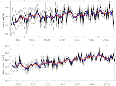
North Atlantic – Winter jet latitude (upper) and winter jet speed (lower) 1871-2011 (Hallam et al. 2022)
Atlantic and North Pacific. Initial results indicate that the jet latitude meridional range is at a minimum in winter along the western boundary of the North Pacific and North Atlantic, where the SST gradients are strongest. Also, during the period 1871-2011, the winter jet latitude in the North Atlantic has migrated 3 degrees poleward and an increase in jet speed of 10mph is observed, both have implications for European Weather (Hallam et al. 2022).
References:
Hallam, S., M. Guishard, S. A. Josey, P. Hyder & J. Hirschi (2021) Increasing tropical cyclone intensity and potential intensity in the subtropical Atlantic around Bermuda from an ocean heat content perspective 1955–2019. Environmental Research Letters, 16, 034052.
Hallam, S., S. A. Josey, G. D. McCarthy & J. J. M. Hirschi (2022) A regional (land–ocean) comparison of the seasonal to decadal variability of the Northern Hemisphere jet stream 1871–2011. Climate Dynamics.
Hallam, S., R. Marsh, S. A. Josey, P. Hyder, B. Moat & J. J. M. Hirschi (2019) Ocean precursors to the extreme Atlantic 2017 hurricane season. Nature Communications, 10, 896.
Applications of Decadal Predictions
Catherine O’Beirne
Fishery sector is of vast importance to the Irish economy. In 2019 it has generated €577 million and employed 16 thousand. The ability to predict changes in the future stock will support adaptation and fish stock management. In decadal climate prediction, initialized predictions have demonstrated improved prediction skill for the North Atlantic. The different stages of fish development are dependent on oceanic variables like temperature and variability and investigating decadal prediction skill for those variables will allow me to make statements on potential changes in fish stock.

After completing a B.A. in Environmental Science at Trinity College Dublin in 2016 and an M.Sc. in Climate Change at Maynooth University in 2018. I am currently a 3rd year PhD candidate at Maynooth University. The area of focus is on understanding Atlantic variability and its connection to the Irish shelf advancing knowledge of Irish sea-level change in an Atlantic context; development of predictive capacity on decadal timescales for the North Atlantic; and how these predictions be applied for stakeholder needs
With the aim being to improve decadal prediction skill in the Northeast Atlantic. For this we apply ensemble subsampling, a process that selects those ensemble members for creating a subsampled ensemble mean, which perform best under evaluation by physically based statistical predictors. Climate modes, like Subpolar Gyre (SPG) and the Atlantic Multidecadal Variability (AMV), interact with our region of interest and therefore we will use those to inform us about our subsampling decisions. Applying this methodology on seasonal scales has demonstrated improved prediction skill for other climate modes.
Historic Sea Level Change and Outreach
Dr Zoe Roseby
I am postdoctoral researcher at Trinity College Dublin, interested in reconstructing past environmental change using sediment cores and microfossils found within them. My current research focuses on producing sea level reconstructions from Ireland, as part of the A4 project.
In addition to my research, I participate in outreach activities on the topics of climate change and sea level rise. I am the lead applicant on Línte na Farraige, a project funded by the Creative Ireland Programme, ‘Creative Climate Action’, which seeks to meaningfully connect people with profound changes happening in our environment, society and economy arising from climate change. Línte na Farraige is a collaborative project including a team of artists, scientists, the Climate Action Regional Offices, local authorities, community groups among others. The project consists of a set of visual light installations by artists Timo Aho and Pekka Niittyvirta, that will be placed across Irish coastal sites in the coming months. Check out the website https://www.creativeireland.gov.ie/en/blog/creative-climate-action-linte-na-farraige/
Prior to my appointment at Trinity College Dublin, I carried out a bachelors and integrated master’s degree in Geological Oceanography at Bangor University and a PhD with British Antarctic Survey (BAS), University of Southampton and Durham University. My PhD project reconstructed the deglacial history of the Anvers Trough, western Antarctic Peninsula shelf.
My research interests stem from my childhood on the Cornish coast and curiosity about the sea. I am passionate about supporting equality and diversity in STEM and sit on the Athena SWAN self-assessment team in the School of Natural Sciences, Trinity College Dublin.
Predicting “Dancing water”
Ashly Uthaman
Waves, the dancing water, are both impressive and frightening. Ocean waves, primarily, generated by surface winds, travel thousands of kilometre from their place of origin. On reaching the shore they dissipate energy by breaking at the surf zone thus making it the most dynamic part. Extreme wave events threaten life, livestock and livelihoods and takes away large part of coast every year. Globally, melting glaciers and ice sheets are causing increase in sea-level rise and coastal extreme events are becoming more severe. Wave predictions can help to save lives and limit the damage caused by severe storms.
After completing my Master’s in Physical Oceanography from Cochin University of Science And Technology (2018), India, I worked as Project Associate (2018 -2020) in National Institute of Oceanography, Goa, India. I was part of project aided by Space Application Centre, Ahmedabad, India. I developed an automated Rip current prediction system for the Goa (West coast of India) using numerical modelling. I am 1st year Phd student at Maynooth University and my work focusses on the decadal wave prediction of Irish coast.
The ocean waves influence the atmosphere above and the ocean below, so it is important to include their effects in wave predictions. Coupled atmospheric and wave model will be used to get complete idea of swells from North Atlantic and the waves near the Irish coast will be simulated by surf zone model.
The AMOC and Climate Change
Dr Levke Caesar
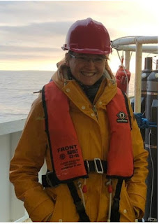
Dr Levke Caesar on a ship expedition in the North Atlantic.
Every second, billions of litres of warm water flow northward near the surface of the Atlantic, while the same amount of cold water in the deeper ocean flows back southward. In this way, an amount of heat equivalent to the energy production of a million nuclear power plants is brought into the North Atlantic. Since much of this heat is released into the atmosphere, it has a significant impact on Europe's climate. The circulation behind all this is called the Atlantic Meridional Overturning Circulation, or short AMOC. Climate models predict a weakening of the AMOC in response to global warming, and scientist have wondered for years whether this slowdown has already begun. One of these scientists is Dr Levke Caesar.As a climate physicists Dr Caesar studies climatic changes in and around the North Atlantic with a special focus on the role and the past evolution of the Atlantic Meridional Overturning Circulation. Since direct continuous measurements of the AMOC only started in 2004, she looks at other climate variables, that can be linked to the strength of the AMOC, to learn more about its past. One example are the sea surface temperatures of the North Atlantic: they are highly affected by the northward heat transport associated with AMOC and reach back until the end of the 19th Century. And indeed, a unique region of cooling temperatures south of Greenland suggests that the system has weakened by about 15 percent since the middle of the 20th century (Caesar et al., 2018). This is in line with the trends found in other proxy data like the grain sizes or the composition of coral shells found in ocean sediments, that all indicate that the AMOC in recent decades has been weaker than ever before in at least 1600 years (Caesar et al., 2021).These findings are particularly interesting for Ireland - not just because it profits from the heat brought northward by the AMOC but also because a such a slowdown of the AMOC has been linked to an enhanced sea-level rise at both sides of the North Atlantic as well as increased storminess in north-western Europe.
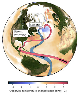
Simplified scheme of the Atlantic Meridional Overturning Circulation and the fingerprint in the sea surface temperatures that is caused by a slowdown in AMOC strength.
References
Caesar, L., McCarthy, G. D., Thornalley, D. J. R., Cahill, N., & Rahmstorf, S. (2021). Current Atlantic Meridional Overturning Circulation weakest in last millennium. Nature Geoscience, 14(3), 118-120. https://doi.org/10.1038/s41561-021-00699-z
Caesar, L., Rahmstorf, S., Robinson, A., Feulner, G., & Saba, V. (2018). Observed fingerprint of a weakening Atlantic Ocean overturning circulation. Nature, 556(7700), 191-196. https://doi.org/10.1038/s41586-018-0006-5
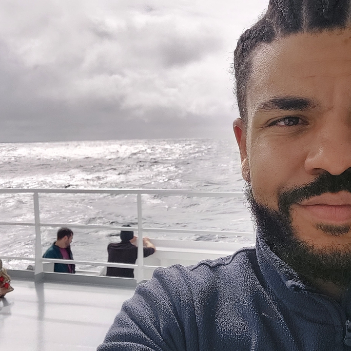 Image credit: Sam T. Diabaté